
Assessment techniques of tropospheric effects for local augmentation systems (TROPSY)
Project partners:
- TeleConsult Austria GmbH (Austria, lead)
- Technical University of Vienna, Department of Geodesy and Geoinformation (Austria)
- Zentralanstalt für Meteorologie und Geodynamik (Austria)
- Budapest University of Technology and Economics, Department of Geodesy and Surveying (Hungary, associate partner)
GNSS and the atmosphere
The global navigation satellite systems (GNSS) measure the travel time of a micorwave signal between the satellites on a known orbit and the receiver in order to compute the receiver-satellite range.
Electromagnetic signals propagate slower in the neutral part of the atmosphere with respect to the propagation velocity in vacuo. Thus the observed range is always larger than the true one. This effect is approximately 2.5 m in the zenith direction, while it can reach the level of 30 metres under low elevation angles.
The upper part of the atmosphere also affects the propagation of the signals. The magnitude of this effect is in the order of 10-15 metres in zenith direction.
Aims
The project aims at an improvement of accuracy tropospheric correction algorithms for design, verification and operations of GNSS systems.
In particular:
- Develop algorithms and input data which reduce the global tropospheric residual error for nominal conditions (1 sigma around mean value) when only data stored in the receiver are used ("blind" mode).
- Assess and model the error distribution of the tropospheric correction algorithms (in all modes of operation) in both nominal and extreme conditions (error values ranging from 1 sigma to 4 sigma around the mean value) to allow the definition of tropospheric error overbounding for integrity purposes in augmentation systems.
- Identify data, algorithms, requirements and performances for the operations of a Local Area Augmentation Systems (LAAS) providing tropospheric correction parameters to GNSS receivers in "augmented" mode (when correction algorithm receives real time parameters applicable for the LAAS coverage area).
- Develop tropospheric space/time channel models to be used for GNSS constellation simulators.
Brief Description
Global Navigation Satellite Systems (GNSS) are based on the broadcasting of electromagnetic ranging signals. The radiowave propagation effects that can affect GNSS are due to: multipath signal propagation, site shielding effects and propagation through the atmosphere of the earth (mostly ionosphere and troposphere). Among those effects, the excess path length due to the troposphere (tropospheric delay) has usually lower impact than the other propagation effects on the navigation solution. However, while other error sources may be mitigated by system design (e.g. use of multi-frequency receivers, modulation schemes and antenna design for multipath mitigation, etc.), the reduction of the tropospheric delay error relies almost exclusively on the use of a correction algorithm (troposphere signal delay model) driven by meteorological data or the use of differential techniques.
The previous ESA Galileo User Receiver model (ESA GALTROPO) has been created 10 years ago as an evolution of the RTCA-MOPS standard. Accounting for increasing demands for accuracy and integrity of GNSS systems it is necessary to revise and improve existing tropospheric error models.
In the frame of TROPSY project a new tropospheric signal delay model will be obtained using the recent meteorological data. The derived model will be tested under different weather conditions, user positions (including locations with height more than 2 km above mean sea level) and on low satellite elevation angles (starting with 2 degrees). On successful tests, the obtained model and correspondent data sets will be submitted to a Regulatory Body for Radio systems (e.g. ITU-R) and for Aviation (e.g., Eurocae, ICAO) for new or updated recommendations.
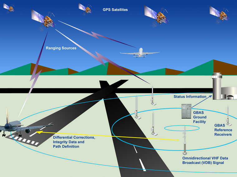
Figure 1. The principle of Ground Based Augmentation Systems (GBAS): The ranging observations of the satellite navigation systems can be imroved by the correction parameters derived by ground based reference stations in order to achieve higher accuracy. Moreover these ground based stations enables the study and monitoring of the integrity of satellite signals. Thus not only higher accuracy, but also higher integrity of the satellite positioning service can be achieved, that is necessary for the safety-of-life applications of GNSS, such as the application in civil aviation. (Photo: FAA)
Funding
TROPSY activities are funded under the ESA contract No. 4000107329/12/NL/LvH. The contribution of BME was funded by and ESA PECS subcontract.
Group leader
Dr. Szabolcs Rózsa, associate professor
Status: succesfully concluded in 2015.